 |
|||||

|
||
|
Our
Hometown Sites
|
T

Select your town below for the fastest way to Community Information. If your town isn't listed, let us know
If you have problems using the drop down list, then
click here to
use our site map.
Our hometown sites offer: Yellow Pages, Classified Ads, Guestbooks & Forums, Community Calendars, History and Trivia. These Community Websites are part of a network of over 1,700 represented within the Hometown Canada Network of Communities. We rely upon and encourage all members of the community to participate in the development of these pages. So come on in and visit with us, see what our great communities have to offer and if you can't find what you are looking for, let us know by posting a question in our Community Forums so that a member of that hometown can reply to you or email you the answer. |
|
||||
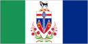
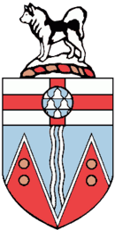
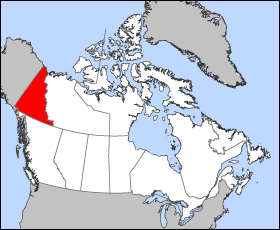
Yukon Territory, CanadaYukon
or Yukon Territory or
(usually) The Yukon is one of Canada's northern territories, in the
country's extreme northwest. It has a population of about 31,000, and
its capital is Whitehorse,
with a population of 23,272. People from Yukon
are known as Yukoners.
Largest municipalities by population
GeographyThe very sparsely populated territory abounds with natural scenic beauty, with snowmelt lakes and perennial whitecapped mountains. Although the climate is arctic and subarctic and very dry, with long cold winters, the long sunshine hours in short summer allow hardy crops and vegetables, along with a profusion of flowers and fruit to blossom. The territory is the approximate shape of a right triangle, bordering the American state of Alaska to the west, the Northwest Territories to the east and British Columbia to the south. Its northern coast is on the Beaufort Sea. Its ragged eastern boundary mostly follows the watershed between the Yukon Basin and the Mackenzie River watershed to the east in the Mackenzie mountains. Canada's highest point, Mount Logan (5959 m), is found in the territory's southwest. Mount Logan and a large part of the Yukon's southwest are in Kluane National Park and Reserve, a UNESCO World Heritage Site. Other National Parks include Ivvavik National Park and Vuntut National Park in the north. Most of the territory is in the watershed of its namesake, the Yukon River. The southern Yukon is dotted with a large number of large, long and narrow glacier-fed alpine lakes, most of which flow into the Yukon River system. The larger lakes include Teslin Lake, Atlin Lake, Tagish Lake, Marsh Lake, Lake Laberge, Kusawa Lake, and Kluane Lake. Lake Bennett, B.C., on the Klondike Gold Rush trail is a smaller lake flowing into Tagish Lake. Other watersheds include the Mackenzie River, the Alsek-Tatshenshini as well as a number of rivers flowing directly into the Beaufort Sea. The two main Yukon rivers flowing into the Mackenzie in the Northwest Territories are the Liard River in the southeast and the Peel River and its tributaries in the northeast. The capital, Whitehorse, is also the largest city, with about two-thirds of the population; the second largest is Dawson City, (pop. 1800) which was the capital until 1952. Other communities include Beaver Creek (88), Burwash Landing (68), Carcross (201), Carmacks (431), Destruction Bay (43), Faro (313), Haines Junction (531), Mayo (366), Old Crow (299), Pelly Crossing (328), Ross River (337), Tagish (206), Teslin (267), and Watson Lake (1,071). PoliticsLike the provinces, and unlike the other two territories, the Yukon's unicameral legislature has a party system. Prior to 1979 the territory was administered by the Commissioner who is appointed by the federal Minister of Indian Affairs and Northern Development. The Commissioner used to chair and had a role in appointing the territory's Executive Council and used to have a day to day role in governing the territory. However, a significant degree of power was devolved in 1979 from the federal government and Commissioner to the territorial legislature which, in that year, adopted a party system of responsible government. The territory is presently represented in Ottawa by a single Member of Parliament. The Yukon Act, passed in 2002, formalised the powers of the Yukon government and devolved a number of additional powers to the territorial government (e.g. control over land and natural resources). As of 2002, other than criminal prosecutions, the Yukon government has much of the same powers as provincial governments and the other two territories are looking to obtaining the same powers. Today the role of Commissioner is analogous to that of a provincial lieutenant-governor however, unlike lieutenant-governors, Commissioners are not formal representatives of the Queen, but are employees of the Federal government. In preparation for responsible government, political parties were organised and ran candidates to the territorial legislature for the first time in 1978. The Progressive Conservatives won these elections and formed the first party government of Yukon in January 1979. The NDP formed the government from 1985 to 1992 under Tony Penikett and again from 1996 under Piers McDonald until being defeated in 2000. The Liberal government of Pat Duncan was razed in elections in November 2002, with Dennis Fentie of the Yukon Party forming the government as Premier. The territory's head of state is a federally appointed Commissioner, a role roughly equivalent to that of a provincial lieutenant governor. The territory has one senator and one member in the Parliament of Canada. Although there has been discussion in the past about the Yukon becoming Canada's 11th province, it is generally felt that its population base is too sparse for this to occur at present. Much of the population of the territory is First Nations. An umbrella land claim agreement representing 7000 members of fourteen different First Nations was signed with the federal government in 1991. Each of the individual First Nations then has to negotiate a specific land claim. To date (December 2004), eleven of the 14 First Nations have a signed agreement. The land belonging to one such nation — the Vuntut Gwitchin — is the northernmost land controlled by Native Americans on the entire North American continent; its administrative center, at Old Crow, is the only such community found north of the Arctic Circle. The territory once had an Inuit settlement, located on Herschel Island off the Arctic coast. This settlement was dismantled in 1987 and its inhabitants relocated to the neighboring Northwest Territories. The island is now a territorial park and is known officially as Qikiqtaruk Territorial Park, Qikiqtaruk being the name of the island in Inuktitut. Yukon was one of eight jurisdictions in Canada to offer same-sex marriage before the passage of Canada's Civil Marriage Act, along with British Columbia, Manitoba, Newfoundland and Labrador, Nova Scotia, Ontario, Quebec and Saskatchewan. EconomyThe territory's historical major industry is mining, including lead, zinc, silver, gold, asbestos and copper. Indeed, the territory owes its existence to the famous Klondike Gold Rush of the 1890s. Having acquired the land from the Hudson's Bay Company in 1870, the Canadian government divided the territory off of the Northwest Territories in 1898 to fill the need for local government created by the influx of prospectors during the Klondike Gold Rush. Thousands of these prospectors, led by the chance at gold, flooded the area, creating a colourful period recorded by authors such as Robert W. Service and Jack London. The memory of this period, as well as the territory's scenic wonders and outdoor recreation opportunities, makes tourism the second most important industry. Manufacturing, including furniture, clothing, and handicrafts, follows in importance, along with hydroelectricity. The traditional industries of trapping and fishing have declined. Today, the government sector is by far the biggest employer in the territory, directly employing approximately 5,000 out of a labour force of 12,500. TransportationIn the past, the major transportation artery was the Yukon River system, both before the Gold Rush and after. As well, the coastal Tlingit people traded with the Athabascan people using passes through the coastal mountains. From the Gold Rush until the 1950s, riverboats plied the Yukon River, most between Whitehorse at the head of navigation and Dawson City, but some going further into Alaska and up to the Bering Sea, and others along tributaries of the Yukon River such as the Stewart River. Most of the riverboats were owned by the British-Yukon Navigation co, an arm of the White Pass and Yukon Route, which also operated a narrow-gauge railway from Skagway, Alaska to Whitehorse. The railway ceased operation in the 1980s with the first closure of the Faro mine. It is now operated as a summer time tourist train. Today, major land transportation routes include the Alaska Highway, which passes through Whitehorse; the Klondike Highway going from tidewater in Skagway, Alaska to Dawson City; the Haines Highway from Haines, Alaska to Haines Junction, Yukon, and the Dempster Highway from the Klondike Highway to Inuvik, Northwest Territories. All these highways, except for the Dempster, are paved. Other highways with less traffic include the Campbell Highway which goes from Carmacks on the Klondike Highway, through Faro and Ross River, and veers south to join the Alaska Highway in Watson L, and the Silver trail which forks off the Klondike Highway at the Stewart River bridge to connect the old silver mining communities of Mayo, Elsa and Keno City. All Yukon communities except one are accessible by mostly paved roads, but air travel is the only way to reach one remote community in the Far North (Old Crow). The air transport infrastructure is well developed with Whitehorse International Airport serving as the hub with direct flights to Vancouver, Calgary, Edmonton, Fairbanks, Juneau and Frankfurt (summer months). Every community is served by an airport, and the air charter industry is quite extensive serving mainly the tourism and mining exploration industries. The above article in gray is licensed under the It
uses material from the
|