 |
|||||

|
||
|
Our
Hometown Sites
|

Select your town below for the fastest way to Community Information. If your town isn't listed, let us know
If you have problems using the drop down list, then
click here to
use our site map.
Our hometown sites offer: Yellow Pages, Classified Ads, Guestbooks & Forums, Community Calendars, History and Trivia. These Community Websites are part of a network of over 1,700 represented within the Hometown Canada Network of Communities. We rely upon and encourage all members of the community to participate in the development of these pages. So come on in and visit with us, see what our great communities have to offer and if you can't find what you are looking for, let us know by posting a question in our Community Forums so that a member of that hometown can reply to you or email you the answer. |
|
||||
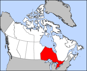
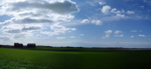
Ontario, CanadaOntario is the most populous and second-largest in area of Canada's ten provinces. It is found in east-central Canada. Its capital is Toronto. Ottawa, the capital of Canada, is also located in Ontario. Ontario has a population (January 1, 2005) of 12,449,502, representing approximately 37.9% of the total Canadian population (Ontarians) and an area of 1,076,395km² (415,598 sq. mi.).
Largest municipalities by population
HistoryPre-1867Before the arrival of the Europeans, the region was inhabited both by Algonquian (Ojibwa, Cree and Algonquin) and Iroquoian (Iroquois and Huron) tribes. The French explorer Étienne Brûlé explored part of the area in 1610-12. The English explorer Henry Hudson sailed into Hudson Bay in 1611 and claimed the area for England, but Samuel de Champlain reached Lake Huron in 1615 and French missionaries began to establish posts along the Great Lakes. French settlement was hampered by their hostilities with the Iroquois, who would ally themselves with the British. The British established trading posts on Hudson Bay in the late 17th century and began a struggle for domination of Ontario. The 1763 Treaty of Paris ended the Seven Years War by awarding nearly all of France's North American possessions (New France) to Britain. The region was annexed to Quebec in 1774. From 1783 to 1796, the United Kingdom granted United Empire Loyalists leaving the United States following the American Revolution 200 acres (0.8 km²) of land and other items with which to rebuild their lives. This measure substantially increased the population of Canada west of the Ottawa River during this period, a fact recognized by the Constitutional Act of 1791, which split Quebec into The Canadas: Upper Canada west of the Ottawa River, and Lower Canada east of it. John Graves Simcoe was appointed Upper Canada's first Governor-General in 1793. American troops in the War of 1812 invaded Upper Canada across the Niagara River and the Detroit River but were successfully pushed back by British and Native American forces. The Americans gained control of Lake Erie and Lake Ontario, however, and during the Battle of York occupied the Town of York (later named Toronto) in 1813. Not able to hold the town, the departing soldiers burned it to the ground. After the War of 1812, many settlers from the British Isles immigrated to Upper Canada, and began to chafe against the aristocratic Family Compact that governed the region, much as the Château Clique ruled Lower Canada. Accordingly, rebellion in favour of responsible government rose in both regions; Louis-Joseph Papineau led the Lower Canada Rebellion and William Lyon Mackenzie led the Upper Canada Rebellion. For more on the rebellions of 1837. Although both rebellions were crushed, the British government sent Lord Durham to investigate the causes of the unrest. He recommended that self-government be granted and that Lower and Upper Canada be re-joined in an attempt to assimilate the Québécois. Accordingly, the two colonies were merged into the Province of Canada by the Act of Union (1840), with Ontario becoming known as Canada West. Parliamentary self-government was granted in 1848. By about 1850, the English-speaking population of Canada West surpassed the French-speaking population of Canada East. A political stalemate between the French- and English-speaking legislators, as well as fear of aggression from the United States during the American Civil War, led the political elite to hold a series of conferences in the 1860s to effect a broader federal union of all British North American colonies. The British North America Act took effect on July 1, 1867, establishing the Dominion of Canada, initially with four provinces: Nova Scotia, New Brunswick, Quebec and Ontario. The Province of Canada was divided at this point into Ontario and Quebec so that each linguistic group would have its own province. Both Quebec and Ontario were required by section 93 of the BNA Act to safeguard existing educational rights and privileges of the Protestant and Catholic minorities. Neither province had a constitutional requirement to protect its French- or English-speaking minority. Toronto was formally established as Ontario's provincial capital at this time. From 1867 to 1896Once constituted as a province, Ontario proceeded to assert its economic and legislative power. In 1872, the lawyer Oliver Mowat became premier, and remained as premier until 1896. He fought for provincial rights, weakening the power of the federal government in provincial matters, usually through well-argued appeals to the Judicial Committee of the Privy Council. His battles with the federal government greatly decentralized Canada, giving the provinces far more power than John A. Macdonald had intended. He consolidated and expanded Ontario's educational and provincial institutions, created districts in Northern Ontario, and fought tenaciously to ensure that those parts of Northwestern Ontario not historically part of Upper Canada (the vast areas north and west of the Lake Superior-Hudson Bay watershed, known as the District of Keewatin) would become part of Ontario, a victory embodied in the Canada (Ontario Boundary) Act, 1889. He also presided over the emergence of the province into the economic powerhouse of Canada. Mowat was the creator of what is often called Empire Ontario. Beginning with Sir John A. Macdonald's the National Policy (1879) and the construction of the Canadian Pacific Railway (1875-1885) through Northern Ontario and the Prairies to British Columbia, Ontario manufacturing and industry flourished. From 1896 to the presentMineral exploitation began in the late 19th century, leading to the rise of important mining centres like Sudbury, Cobalt and Timmins. The province harnessed its water power to generate hydro-electric power, and created the state-controlled Hydro-Electric Power Commission of Ontario, later Ontario Hydro. The availability of cheap electric power further facilitated the development of industry. In 1904, the Canadian automobile industry was launched in what is now Windsor, Ontario with the establishment of the Ford Motor Company of Canada. General Motors of Canada Ltd. was formed in 1918. The motor vehicle industry would become the major industrial component of the Ontario economy. In July 1912, the Conservative government of Sir James P. Whitney issued Regulation 17 which severely limited the availability of French-language schooling to the province's French-speaking minority. French-Canadians reacted with outrage, journalist Henri Bourassa denouncing the "Prussians of Ontario". It was eventually repealed in 1927. Influenced by events in the United States, the government of Sir William Hearst introduced prohibition of alcoholic drinks in 1916 with the passing of the Ontario Temperance Act. Prohibition came to an end in 1927 with the establishment of the Liquor Control Board of Ontario by the government of George Howard Ferguson. The sale of liquor and beer is still tightly-controlled by the state to ensure that the maximum revenues go to the provincial treasury. The post-World War II period was one of exceptional prosperity and growth. Ontario, and the Greater Toronto Area in particular, have been the recipients of most immigration to Canada. Changes in federal immigration law have led to a massive influx of non-Europeans since the 1980s. From a largely ethnically British province, Ontario has now become very culturally diverse. The nationalist movement in Quebec, particularly after the election of the Parti Québécois in 1976, contributed to driving many businesses out of Quebec to Ontario, and Toronto surpassed Montreal as the largest city and economic centre of Canada. Territorial Evolution 1788-1899Land was not legally subdivided into administrative units until a treaty had been concluded with the native peoples ceding the land. In 1788, while part of the Province of Quebec (1763-1791), southern Ontario was divided into four districts: Hesse, Lunenburg, Mecklenburg, and Nassau. In 1792, the four districts were renamed: Hesse became the Western District, Lunenburg became the Eastern District, Mecklenburg became the Midland District, and Nassau became the Home District. Counties were created within the districts. By 1798, there were eight districts: Eastern, Home, Johnstown, London, Midland, Newcastle, Niagara and Western. By 1826, there were eleven districts: Bathurst, Eastern, Gore, Home, Johnstown, London, Midland, Newcastle, Niagara, Ottawa, and Western. By 1838, there were twenty districts: Bathurst, Brock, Colbourne, Dalhousie, Eastern, Gore, Home, Huron, Johnstown, London, Midland, Newcastle, Niagara, Ottawa, Prince Edward, Simcoe, Talbot, Victoria, Wellington and Western. In 1849, the districts of southern Ontario were abolished by the Province of Canada and county governments took over certain municipal responsibilities. The Province of Canada also began creating districts in sparsely populated Northern Ontario with the establishment of Algoma District and Nipissing District in 1858. The northern and western boundaries of Ontario were in dispute after Confederation. Ontario's right to Northwestern Ontario was determined by the Judicial Committee of the Privy Council in 1884 and confirmed by the Canada (Ontario Boundary) Act, 1889 of the Parliament of the United Kingdom. By 1899, there were seven northern districts: Algoma, Manitoulin, Muskoka, Nipissing, Parry Sound, Rainy River, and Thunder Bay. Four more northern districts were created between 1907 and 1912: Cochrane, Kenora, Sudbury and Temiskaming. GeographyOntario is bounded on the north by Hudson Bay and James Bay, on the east by Quebec, on the west by Manitoba, and on the south by the American states of Minnesota, Michigan, Ohio, Pennsylvania and New York. Ontario's long American border is formed almost entirely by lakes and rivers, starting in Lake of the Woods and continuing to the Saint Lawrence River near Cornwall; it passes through the four Great Lakes on which Ontario has coastline, namely Lakes Superior, Huron (which includes Georgian Bay), Erie, and Ontario (for which the province is named; Ontario itself is an Iroquois word meaning "beautiful lake" or "beautiful water"). There are approximately 250,000 lakes and over 100,000 kilometres of rivers in the province. The province consists of three main geographical regions:
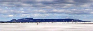
The northern extent of the Carolinian forest zone is found in the southwestern section. The Saint Lawrence Seaway allows navigation to and from the Atlantic Ocean as far as Thunder Bay in Northern Ontario. Northern Ontario occupies 90 per cent of the surface area of the province; Southern Ontario contains 90 per cent of the population. Point Pelee National Park is a peninsula in southwestern Ontario (near Windsor, Ontario and Detroit, Michigan) that extends into Lake Erie and is the part of Canada's mainland furthest south. Pelee Island in Lake Erie is even further south. Both are south of 42°N and further south than the northern border of California.
WeatherThe weather in Ontario is very diverse. Areas such as Chatham and Windsor experience 15-30 days above 30°C or 86°F. The Greater Toronto Area also receives very hot weather in the summer, as Bermuda highs bring a return flow of hot weather into the region. In the winter, snow squalls affect three primary areas in Ontario known as the "snow belts", primarily regions adjacent to the Great Lakes. At other times, some additional areas may encounter snow squalls.
GovernmentThe British North America Act 1867 section 69 stipulated "There shall be a Legislature for Ontario consisting of the Lieutenant Governor and of One House, styled the Legislative Assembly of Ontario". The assembly has 103 seats representing ridings elected in a first-past-the-post system across the province. The legislative buildings at Queen's Park in Toronto are the seat of government. Following the Westminster system, the leader of the party currently holding the most seats in the assembly is known as the "Premier and President of the Council" (Executive Council Act R.S.O. 1990). The Premier chooses the cabinet or Executive Council whose members are deemed "ministers of the Crown". Although the Legislative Assembly Act (R.S.O. 1990) refers to members of the assembly, the legislators are now called MPPs (Members of the Provincial Parliament) in English and députés de l'Assemblée législative in French, but they have also been called MLAs (Members of the Legislative Assembly), and both are acceptable. The title of Prime Minister of Ontario, while permissible in English and correct in French (le Premier ministre), is generally avoided in favour of "Premier" to avoid confusion with the Prime Minister of Canada. DemographicsThe major racial/ethnic groups in Ontario are:
Increasing immigration from all parts of the world, especially to Toronto and its environs, is rapidly diversifying the province's ethnic makeup. About five per cent of the population of Ontario is Franco-Ontarian. EconomyOntario's rivers, particularly its share of the Niagara River, make it rich in hydroelectric energy. This competitive advantage, as well as excellent transportation links to the American heartland, has contributed to making manufacturing the principal industry, found mainly in the Golden Horseshoe region, the most industrialized area in Canada. Important products include motor vehicles, iron, steel, food, electrical appliances, machinery, chemicals, and paper. Ontario rivals the American state of Michigan in car production, assembling 2.696 million vehicles in 2004. Some economists believe that the North American Free Trade Agreement has led to a decline in manufacturing, and that there is evidence that Ontario is part of North America's manufacturing "Rust Belt". Toronto is the centre of Canada's financial services and banking industry. The technology sector is also important, especially around Markham, Waterloo and Ottawa. Mining and the forest products industry, notably pulp and paper, are important to the economy of the Canadian Shield of Northern Ontario. Nominal Gross Domestic Product in 2003 was an estimated C$494.229 billion (40.6% of the Canadian total), larger than the GDP of Austria, Belgium or Sweden. Broken down by sector, the primary sector is 1.8% of total GDP, secondary sector 28.5%, and service sector 69.7%. Agriculture
The above article in gray is licensed under the It
uses material from the
|

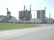 Once
the dominant industry, agriculture occupies a small percentage of the
population. The number of farms has decreased from 68,633 in 1991 to
59,728 in 2001, but farms have increased in average size. Cattle, small
grains and dairy were the common types of farms in the 2001 census.
The fruit, grape and vegetable growing industry is located primarily
on the Niagara Peninsula and along Lake Erie. The
Once
the dominant industry, agriculture occupies a small percentage of the
population. The number of farms has decreased from 68,633 in 1991 to
59,728 in 2001, but farms have increased in average size. Cattle, small
grains and dairy were the common types of farms in the 2001 census.
The fruit, grape and vegetable growing industry is located primarily
on the Niagara Peninsula and along Lake Erie. The