 |
|||||

|
||
|
Our
Hometown Sites
|

Select your town below for the fastest way to Community Information. If your town isn't listed, let us know
If you have problems using the drop down list, then
click here to
use our site map.
Our hometown sites offer: Yellow Pages, Classified Ads, Guestbooks & Forums, Community Calendars, History and Trivia. These Community Websites are part of a network of over 1,700 represented within the Hometown Canada Network of Communities. We rely upon and encourage all members of the community to participate in the development of these pages. So come on in and visit with us, see what our great communities have to offer and if you can't find what you are looking for, let us know by posting a question in our Community Forums so that a member of that hometown can reply to you or email you the answer. |
|
||||
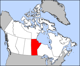
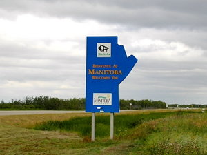
Manitoba, Canada
Geography
The province has a coast with Hudson Bay, and contains the very large Lakes Winnipeg, Manitoba (its namesake), and Winnipegosis. Important watercourses include the Red River, Assiniboine River, Nelson River, Winnipeg River, Hayes River and Churchill River. It is generally flat and low-lying though there are some hilly areas in the province. Baldy Mountain is the highest point at 831m (2,727 feet) and the Hudson Bay coast the lowest at sea level. Other upland areas include Riding Mountain, and the Pembina Hills. The climate in Manitoba is typical of its mid continent location and northerly latitude. In general, temperatures and precipitation decrease from south to north. Summers are generally warm to hot and winters very cold. Both spring and autumn are contracted seasons. As Manitoba is far removed from the moderating influences of both mountain ranges and large bodies of water (all of Manitoba's lakes freeze during the winter months), and because of its generally flat landscape, it is exposed to numerous weather systems throughout the year including prolonged cold spells in the winter months when arctic high pressure air masses settle over the province. This has resulted in the capital of the province being nicknamed "Winterpeg". In the summer months the climate is often influenced by low pressure air masses originating in the Gulf of Mexico resulting in hot and humid conditions and frequent thunderstorms. Only the southern parts of the province support extensive agriculture. The northern reaches of the province range through coniferous forests, muskeg, and up to tundra in the far north. There is approximately 24,000 square miles of untouched boreal forest on the eastern side of Lake Winnipeg. This area is renowned by naturalists and sportsmen for its pristine wilderness. Largest municipalities by population
DemographicsEthnic originNote: the percentages do not necesarily add up to 100% as multiple responses are allowed.
Ethnic origins with less than 3% of the responses are not listed. Religious groups
Religions that make up less than 1% are not listed. History
The territory was won by Britain in 1763 as part of the French and Indian War, and became part of Rupert's Land, the immense monopoly territory of the Hudson's Bay Company. The founding of the first agricultural community in 1811 by Lord Selkirk, near modern Winnipeg, resulted in conflict between the white colonists and the Métis who lived near there. Twenty colonists, including the governor, were killed by the Métis in the Battle of Seven Oaks in 1816. When Rupert's Land was ceded to Canada in 1869 and incorporated into the Northwest Territories, a lack of attention to Métis concerns led their leader Louis Riel to establish a provisional government, The Red River Rebellion. Negotiations between this government and the Canadian government resulted in the creation of the province of Manitoba and its entry into Confederation in 1870. Originally the province was only 1/18 of its current size and square in shape - it was known as the "postage stamp province." It grew progressively, absorbing land from the Northwest Territories until it attained its current size by reaching 60°N in 1912. The above article in gray is licensed under the It
uses material from the
|

 Manitoba
is located in the longitudinal centre of
Manitoba
is located in the longitudinal centre of  Manitoba
was settled by members of the Ojibwa and Assiniboine tribes. The first
European to reach present-day Manitoba was Sir Thomas Button, who visited
the Nelson River in 1612. Pierre Gaultier de Varennes, Sieur de la Vérendrye,
visited the Red River Valley in the 1730s as part of opening the area
for French exploration and exploitation. An important French-Canadian
population (Franco-Manitobains) still lives in Manitoba, especially
in the Saint-Boniface district of
Manitoba
was settled by members of the Ojibwa and Assiniboine tribes. The first
European to reach present-day Manitoba was Sir Thomas Button, who visited
the Nelson River in 1612. Pierre Gaultier de Varennes, Sieur de la Vérendrye,
visited the Red River Valley in the 1730s as part of opening the area
for French exploration and exploitation. An important French-Canadian
population (Franco-Manitobains) still lives in Manitoba, especially
in the Saint-Boniface district of